This independent proposal builds on a previous large scale zoning study that included an array of properties owned by the New York City Housing Authority (NYCHA). The goal of the previous study was to quantify the development rights currently available to the agency, as well as to identify potential in-fill sites within public housing projects.
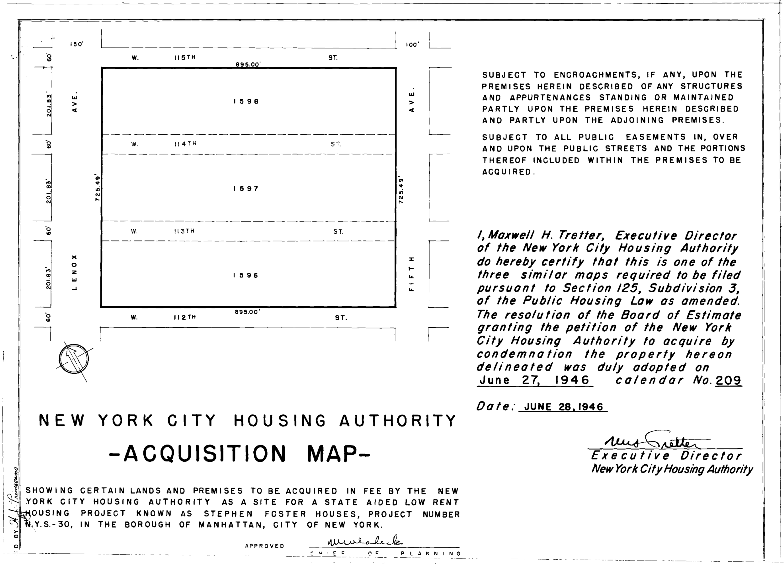
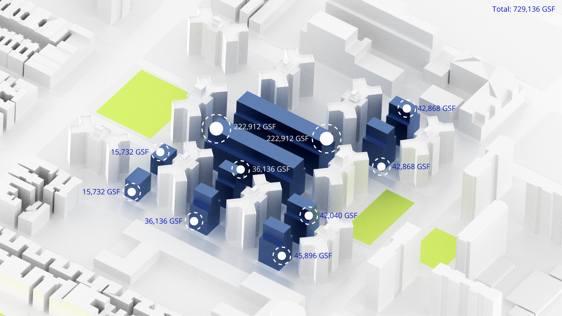
King Towers was constructed in 1957 and contains approximately 1,376 dwelling units. This proposal dealt with the possibility of up-zoning the development from an R7-2 district to a contextual R7X district, while mapping an Inclusionary Housing Designated Area into the parcels in question. The proposal also assumed a special permit for a large-scale residential development which would allow for the unrestricted transfer of floor area across all the parcels which we proposed be created though a very specific subdivision scheme. The current buildings are approximately 13 to 14 stories tall and between 113′ and 125′ feet tall. The most similar contextual district, which would also provide the housing authority with the various options for development, has been noted to be an R7X, which provides for a minimum base height of 65′, a maximum base height of 85′ and a maximum building height of 125′.
Mapping an Inclusionary Housing Development Area into the rezoning would allow NYCHA to set aside all or parts of the new development as Housing Preservation Department (HPD)-designated affordable housing, which could then then be created and operated by third party developers working under an existing framework for affordable housing. This framework creates guidelines for the quality, mix and income ranges for the particular units that designated as affordable. The particulars of the Inclusionary Housing framework and its interaction with the R7X district, the potential in-fill areas and the built floor areas would also allow NYCHA to set forth its own affordability percentages while still complying with applicable zoning regulations; potentially creating its own mix (not necessarily the typical 80/20), while still making use of HPD program. Our aim was to create a large-scale residential development where multiple options for construction and compliance are possible, and where NYCHA retains its current development used and unused development rights should it choose to redevelop King Towers in the future.
The original parcels, as seen in the acquisition maps for King Towers, included portions of the street grid which were subsequently de-mapped, but which are still used as circulation spaces. We proposed the remapping of the street grid into the existing development as means of accessing the larger potential in-fill areas that would have otherwise remained “landlocked” by the existing buildings. We proposed this as a first step towards re-integrating King Towers into the fabric of the city, and as an attempt at creating a second model case for remapping street grids into existing public housing developments (St. Nicholas Houses had recently done just that).
The unofficial city policy, as practiced by the Department of City Planning has been to rezone around public housing developments, purposely excluding the developments from study areas, special districts and newly rezoned areas. The result has been a relative reduction (proportional to the relative up-zoning of most parts of the city in last 40 years) of the development potential for sites owned by NYCHA. Our proposal ran counter to this trend and attempted to encourage NYCHA to take on a proactive position where the agency asserts that its current exclusion from city-driven planning efforts are part of the reason why public housing developments in megablocks have remained so isolated from the bustling economies that surround them. We consciously chose a zoning district that allows NYCHA to retain the existing surplus of development rights present in King Towers, while also allowing it to develop more affordable housing within underused areas of the site.